| A little history on these maps | Scanning and digital versions | Prices |
The “Reorganization Commission” (October 2, 1885 – April 14, 1886)
A Royal Decree of September 2, 1885 appointed the members of the “Reorganization Commission” (active from 1885 to 1886), which was to propose a new text (the basis for a new Royal Decree) organizing the execution of a new detailed geological map.
The members of the Commission adopted the following points for the elaboration of the map:
The “Geological Survey of Belgium” (1890-1919)
Nothing happened on the geological map front for 4 years, until the Royal Decree of December 31, 1889. It should be noted that the Geological Map Service was placed within the remit of the General Directorate of Mines.
The Royal Decree of 1889 established a Geological Survey of Belgium, consisting of a Board of Directors and an unspecified number of collaborators.
The Board, made up of the General Director of Mines and 7 geologists appointed by Royal Decree:
Collaborators are appointed by A.M. on the recommendation of the Board of Directors. Samples collected during the surveys will be kept by the Royal Museum of Natural History (i.e. RBINS today).
The members of the Board of Directors appointed by R.D. are: Mr Arnould, General Director of Mines; Messrs Dewalque, Briart, de la Vallée Poussin, Malaise, Rutot, Van den Broeck and Mourlon.
This organization led to the publication of most of the 1:40 000 scale-maps between 1890 and 1903. The work was not fully completed until 1919.
Mapping work
The collaborators
The collaborators undertook to submit a 1:20 000 scale-map, including outcrops, geological boundaries, etc., and a 1:40 000 scale-map, for publication on the advice of the Board.
The deadline for each planchette was one year, but collaborators were fast to ask for extensions. Remuneration was set at 2400 Belgian Francs (in 1890) per planchette, with modulations according to the complexity of the map.
The work of the collaborators was subject to approval by 2 members of the Board, who were appointed as rapporteurs. The rapporteurs often went out into the field with the cartographer to verify the validity of some interpretations.
The stratigraphic legend
The development of the stratigraphic legend took almost 17 months (March 1891 to August 1892). The Tertiary and Quaternary legends were the result of a project by Mourlon. The Secondary legend was discussed on the basis of a draft by Dewalque. Proposals by Malaise for the Silurian, by Dewalque and Malaise for the Cambrian, and by Briart for the Houiller were adopted.
On the other hand, the Devonian and Carboniferous Limestone were hotly debated. Disputes arose over the interpretation of the Waulsortian, the Grande Brèche and the dolomitic series within the Carboniferous limestone. The legend was revised between 1894 and 1895.
The Devonian and Frasnian stages in particular were hotly debated. The second version of the stratigraphic scale was adopted in April 1896. In 1900, further modifications were added, including the descent of the Wealdian into the Jurassic and the Ottrelite schists.
Technical problems
Printing was under the direction of the Military Cartographic Institute. The following figuration was adopted by the Council for reasons of simplicity and lower cost:
The board decided on a definitive range of colours in 1892, revised in 1896. These colours were to be as close as possible to the shades used by Dumont and to the dominant colouration of the lithology of the floor.
All that was missing was the Hastière-Lavaux sheet in 1903, produced by de Dorlodot and Kaisin. This geological map was not published until 1919.
In parallel with the publication of these geological maps, the Military Cartographic Institute printed a 1/160 000 scale map, which was first exhibited in Liège in 1905.
In conclusions
Belgium could be proud of its first large-scale geological map, a world first; other European countries would have to wait several decades for similar results.
It should also be noted that the geological map was presented at numerous exhibitions, including those in Paris (1900) and Brussels (1910).
The Geological Survey was created by Royal Decree in 1896, and its Director was none other than Mourlon. Mourlon played an essential role in advancing the work on the geological map of Belgium.
In particular, he took advantage of his position to unify the travel notes of the map’s collaborators and use them as the basis for the archives of the Geological Survey of Belgium.
In 1919, J. Wauters, Minister of Industry, Labor and Supply, announced to King Albert the completion of the geological map in his report to the King.
Find out more
This text is a synthesis of data published by:
F. Boulvain (1993) – Un historique de la carte géologique de Belgique – Professional Paper n°262, 1993/4, 63 pages and 24 pages of appendices.
This Professional Paper is available for consultation at the Geological Survey of Belgium bookshop.
| introduction | the product GIS-Geological maps | computer data | pack prices | how to contact us |
The Geological Survey of Belgium (GSB) has compiled data on belgian geology since its creation in 1896. Geological maps, published one century ago, at scale 1:40 000 are hosted at GSB. The greatest part of these maps (numbered from 1 to 226) has been edited between 1893 and 1905 by the “Geological Commission”, active during the period 1890-1919. Belgium was the first country to possess a complete geological map at such a level of details.
Nine geological maps at scale 1:25 000 have been published after the second world war by the “Geological Council” (1947-1977). They concern the Mons basin (Prof. Marlière) and a part of the “Stavelot Massif” (Profs. Fourmarier, Asselberghs et Geukens).
The maps (numbered from 227 to 236), corresponding to the eastern part of Belgium, have never been published (figure 1) because the “Eastern Cantons” were not Belgian at that time.
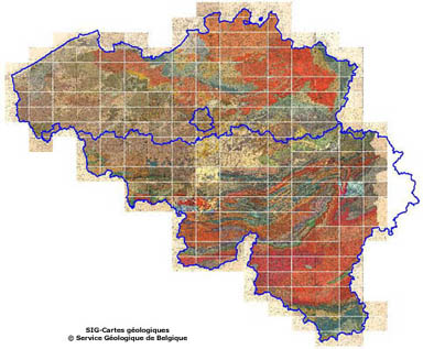
Figure 1 shows the assembly of the 226 geological maps (rasters) with the delimitation (in blue) of the three regional boundaries (Flanders, Brussels and Wallonia) within the GIS.
One of the GSB missions concerns its own geological data computerization. Geological maps at scale 1/40.000 have been digitized; the rasters have been georeferenced, vectorized (figure 2) and assembled in one numerical geological map . Note that the definition of the vectorization procedure has been realized at scale 1:40 000 using a digitalized table.
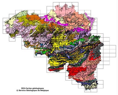
Figure 2 shows the assembly of the 226 geological maps (vectors) with the delineation (in black rectangles) of the geological map grid within the GIS. As you can see, 10 geological maps have not been produced in the eastern part of Belgium (eastern cantons).
The geological map is a chronostratigraphic map and the original legend has been totally preserved. Every polygons of the vectorial map correspond to a geological system, stage or even to other stratigraphical subdivisions. On the other hand, complementary informations indicating local lithological variations as well as rock types (recognized by boreholes) are figured on the geological maps. Each map has its own specific legend that has been completely preserved.
Digitalization is directly related to the scale 1/40.000. At a greater scale, a systematic deviation will appear between raster and vector maps. For this reason, we recommand the use of the vector maps at scale 1/40.000. It must be noted that the precision on these geological maps is linked to the cartographic projection in use during the publication of these maps at the end of the 19th century.
Until today, no modification has ever been considered to adjust the observed differences between neighbouring maps on similar cartographical unit boundaries.
Georeferenced and vectorized raster geological maps (version 1.1) are available for sale: for the whole country but also by packs of nine maps.
Raster files will be avalaible as “.tif” format with indexed colors at 150 dpi. The size of each raster file is around 3,4 Mo.
Vectorial files will be available as “.tab” format for MapInfo users and “.shp” format for ArcView users .
These products are made for universities, private consultants, public administrations that are interested (for example, to use such tools for GIS applications in territory planning).
A new version (1.2) should integrate final corrections and small bugs, better juxtapositions between raster and vector data. This second version will be given for free to the buyers of the first version.
All the geological maps (raster and/or vector files) including the GIS files and the legends document are delivered in a digital zip file using a secured transfer file server at the following prices:
PACK (A): Price (VAT included)
Every geological maps of Belgium at scale 1/40.000 digital and georeferenced for GIS applications:
– 300 € (price for public institution)
– 500 € (price for enterprise)
PACK (B): Price (VAT included)
Every geological maps of Belgium at scale 1/40.000 georeferenced and vectorized for GIS applications:
– 800 € (price for public institution)
– 1200 € (price for enterprise)
PACK (C): Price (VAT included)
Package of nine neighbouring geological digitized and georeferenced maps (choice of central map by the buyer):
– 30 € (price for public institution)
– 50 € (price for enterprise)
PACK (D): Price (VAT included)
Package of nine neighbouring geological georeferenced and vectorized maps (choice of central map by the buyer):
– 80 € (price for public institution)
– 120 € (price for enterprise)
| This product is available for sale at the GSB. For ordering, please contact – gsb@naturalsciences.be |
